
This guide covers a few Brisbane CBD and South Brisbane arcades and laneways that have council or State Library of Queensland (SLQ) heritage information. It reports history, listing details and the councils’ own wording, and leaves out tenants, shops, opening hours and events.
Brisbane Arcade
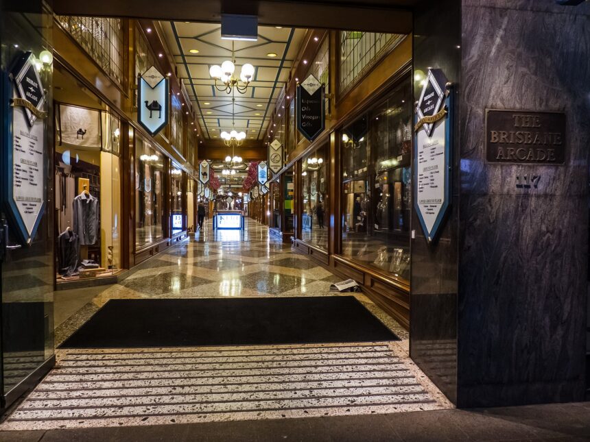
Brisbane City Council’s City Centre heritage trail page says Brisbane Arcade was built in 1924 and is the city’s oldest surviving shopping arcade. The same page says philanthropists James Mayne and his sister Mary Amelia built it at a cost of £70,000. It says James died in 1939 and Mary a year later, and that the University of Queensland then became the beneficiary of the property.
SLQ, in a post dated 3 May 2024, says the arcade was designed by Richard Gailey Jr. for Dr James Mayne and Mary Emelia Mayne. The two sources spell the sister’s middle name differently, as Amelia in the Council text and Emelia in the SLQ text, and this article does not choose between them. SLQ describes Edwardian Baroque style street facades, original terrazzo stairs, intricately crafted balustrades and dado paneling. The Council page says the arcade has undergone substantial refurbishment, in 1983 and in 1990, and that the arcade also provided a well-used pedestrian link between Queen Street and Adelaide Street.
The Council’s heritage register lists addresses for the place that include 166 Queen Street and 117 Adelaide Street. The register page, revised April 2021, shows a Queensland Heritage Register entry date of 21 October 1992.
Broadway Arcade facade
The Council’s heritage register says the Adelaide Street frontage of the Broadway Arcade contains the facades of two distinct buildings. It says the former Stewart and Hemmant warehouse was built in 1886 to a design by George Cowlishaw, as an extension to the company’s Queen Street premises. The adjacent facade was constructed as the Fitzroy Building in 1912. The register adds that in 1923 the premises were acquired by Commerce House (Queensland) Ltd, and that the 1919 date in the pediment refers to the formation of that commercial entity. At 10 November 2026, the register shows the facade at 133 Adelaide Street as a local heritage place since 30 October 2000.
Beatrice Lane
The Council’s heritage register entry for Beatrice Lane, citation dated January 2008 and page revised September 2020, says the L-shaped lane connects Margaret Street to Albert Street. It says the lane was built circa 1887 to service the buildings on that section of Margaret Street, and by 1895 had been extended to Albert Street. Porphyry (Brisbane tuff) stonework was laid in two rows to provide a carriageway for wagons and drays, most likely around 1895, according to the register.
The register says the area bounded by George, Edward, Elizabeth and Alice Streets was known colloquially as ‘Frogs Hollow’ because it was low-lying, swampy ground. It says the lane was originally an unnamed side lane and was given the name Beatrice Lane circa 1989. It adds that around the same time the Council erected street signage to mark the entrance to each lane. The register says that during the twentieth century these lanes also became a quick way for city workers to cross from one block to another, avoiding road traffic and crowds.
The register states that Beatrice Lane remains the only Central Business District laneway with exposed porphyry stonework. It also describes the lane as the only remaining private service lane that acts as a vehicular thoroughfare between two CBD streets. At 10 November 2026, the register shows it as a local heritage place since 1 January 2009.
Lanes the Council records as lost
The same Beatrice Lane citation lists CBD lanes lost to later development, among them Parbury Lane, lost to the Brisbane Riverside Markets and Riparain Plaza redevelopment, and Old Burnett Lane, which it says disappeared when the Criterion Hotel was redeveloped as a high-rise building. It says Isle Lane was halved in size and ceased to be a thoroughfare between Adelaide and Queen Streets when Post Office Square and its underground car park were built. As of the January 2008 citation, it counted 14 remaining public and private lanes across the CBD, of which only six were similar to Beatrice Lane in providing access between two streets. The Council’s heritage trail page separately records that the first Methodist church in Brisbane, built in 1849, stood on the corner of Albert Street and Burnett Lane and was replaced by a larger church in 1856.
Fish Lane
The Council’s heritage register entry for Fish Lane (citation September 2001) says the lane existed as an access track from the 1870s and was given the name Soda Water Lane in 1885. It says the name was derived from the Eodone Aerated Water Company, one of the first occupants of the lane. In 1904 the South Brisbane council approved a name change in honour of George Fish. The register says Fish was elected as an alderman on that council from 1894 to 1907.
The register says the lane was extended through to Manning Street in 1924 and upgraded to street status in 1931, and that the decline in South Brisbane’s commercial centre from the 1950s saw Fish Street revert to a laneway. It says Fish Lane became the longest of the twelve lanes that fed service vehicles to the businesses in South Brisbane’s commercial centre. The register states that with the demolition of much of South Brisbane’s commercial centre for Expo 88, all of the area’s service lanes were lost, except Fleet Lane and Fish Lane. At 10 November 2026, it shows Fish Lane as a local heritage place since 1 January 2004.
The City Centre heritage trail
The Council’s Brisbane City Centre Heritage Places trail has 25 points of interest through the CBD and Spring Hill. Brisbane Arcade is stop 2 on that trail.
Related reading
Brisbane Heritage-Listed Buildings Guide; The History of South Bank; Expo 88 and How It Changed Brisbane; A Short History of Brisbane.
Frequently asked questions
When was Brisbane Arcade built?
Brisbane City Council’s City Centre heritage trail page says it was built in 1924 and is the city’s oldest surviving shopping arcade.
What is special about Beatrice Lane?
At 10 November 2026, the Council heritage register (citation January 2008, page revised September 2020) says Beatrice Lane remains the only Central Business District laneway with exposed porphyry stonework.
Why is it called Fish Lane?
The Council heritage register says it was given the name Soda Water Lane in 1885 and that in 1904 the South Brisbane council approved a change in honour of George Fish.