

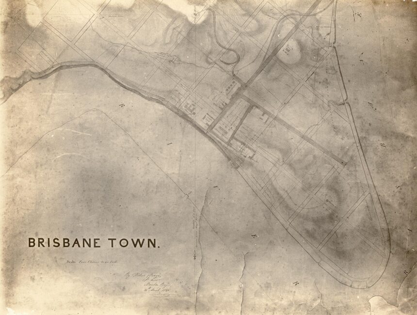
Brisbane’s central grid carries royal names, and several other street and place names have an origin stated in a library, place-history or council source. This article reports only what those sources say, attributes each to its publisher, and flags the places where they differ in wording.
- The royal grid of the CBD
- How Queen Street set the pattern
- Creek Street and Wheat Creek
- Boundary Street and the town limits
- Spring Hill, Wickham Terrace and Jacob’s Ladder
- West End, Woolloongabba and Stones Corner
- Squares, terraces and lanes renamed
- Where the record runs out
- Related reading
- Frequently asked questions
The royal grid of the CBD
The State Library of Queensland (SLQ), in a blog post dated 30 September 2010, says central street names were chosen from British royalty, with streets running north-east named after queens. The SLQ Queen Street history lists the queens as Ann, Adelaide, Elizabeth, Queen, Charlotte, Mary and Margaret. The same history says streets running north-west were named after kings, including William, George, Albert and Edward.
Queensland Places, a place-history site, describes the layout in its Brisbane Central entry. It says streets running parallel to Queen Street were named after British and related royalty, among them Queen Mary II, Queen Charlotte (wife of George III) and Queen Adelaide (wife of William IV). SLQ’s list says only “Mary”, while Queensland Places says Queen Mary II, so the two sources are worded differently on that name. Queensland Places adds that William, George, Albert and Edward Streets, running at right angles, had similar royal antecedents.
How Queen Street set the pattern
Queensland Places says the street layout developed from a thoroughfare running north-east from the river’s edge to the prisoners’ barrack near the corner of today’s Queen and Albert Streets. It says that when a town survey was done in 1840 this thoroughfare was chosen as the main street, Queen Street, and the grid of square blocks moved out from the Queen Street axis. SLQ, in a post dated 5 July 2012, says Queen Street began as little more than a track leading from the main part of the early Moreton Bay Penal Colony, and that Surveyor Dixon had surveyed the town’s streets in early 1840.
On widths, Queensland Places says the proposed streets varied from 20 to 28 metres wide, and that Governor Gipps trimmed them back to the lesser figure. The same entry says the street’s unusual width has provided for a signature shopping mall, and that Andrew Petrie apparently persuaded Governor Gipps on this point. The page words the two statements separately, and this article does not reconcile them.
Creek Street and Wheat Creek
Queensland Places says Creek Street’s position approximated the course of a minor stream, Wheat Creek. The entry does not describe how the street received its name, so this article draws no conclusion beyond the stated position.
Boundary Street and the town limits
SLQ, in a post dated 6 August 2008, says an early attempt at town planning in 1846 set the town limits of Brisbane. It describes Boundary Street in Spring Hill and Boundary Street in West End as the northern and western boundaries, with Vulture Street marking the southern boundary and Wellington Street in East Brisbane the original eastern boundary. Brisbane City Council’s Spring Hill Heritage Trail page says Boundary Street was the original town boundary when Brisbane’s town limits were proclaimed. Queensland Places records that the Fortitude immigrants of 1849 were settled outside the town boundary, north of Boundary Street.
Spring Hill, Wickham Terrace and Jacob’s Ladder
Queensland Places says the dividing boundary between Spring Hill and the city is Wickham Terrace. It says the rising landscape was a source of spring water, and that land sales took place in Wickham Terrace and Leichhardt Street in 1856. The Council’s Spring Hill Heritage Trail page says the valley where Water Street now runs was originally called Spring Hollow.
A different kind of name is Jacob’s Ladder, the steep set of steps linking Edward Street and Wickham Terrace. The Council’s City Centre heritage trail page says the steps have linked the two streets since the early twentieth century, and that the name originates from the Biblical tale of Jacob. It adds that the name has been used across the world for steep inclines and long sets of steps.
West End, Woolloongabba and Stones Corner
SLQ says the name West End is believed to be derived from the area of London by the same name, while Queensland Places says the name is presumed to have been inspired by West End, London. Queensland Places also records that West End’s Aboriginal name was Kurilpa.
The Council’s Woolloongabba Heritage Trail page says Woolloongabba is believed to be an Aboriginal word meaning ‘fight talk place’. Its Stones Corner Heritage Trail page says Stones Corner takes its name from early European resident James Stone, who bought land between Logan and Cleveland Roads in 1875, and that the surrounding wetland was known as Burnett Swamp, most likely named after explorer James Charles Burnett.
Squares, terraces and lanes renamed
The Council’s City Centre trail page says the gardens in front of City Hall were known as Albert Square when City Hall opened in 1930, and that the square was renamed King George Square in 1938 when a statue of the British monarch was unveiled. The Council’s heritage register says Heussler Terrace in Milton was named for local landowner John Heussler, and that sections of the street name were changed during World War I when many German names were altered.
For lanes, the Council heritage register says Fish Lane in South Brisbane was given the name Soda Water Lane in 1885, a name derived from the Eodone Aerated Water Company, one of the first occupants of the lane. It says that in 1904 the South Brisbane council approved a change to Fish Lane in honour of George Fish. The Council’s Beatrice Lane entry says that lane was originally an unnamed side lane and was given the name Beatrice Lane circa 1989.
Where the record runs out
The pages read for this article state some origins and are silent on others. Where a library, place-history or council page gives no origin, this article gives none.
Related reading
The Story Behind the Name Brisbane; A Short History of Brisbane; History of West End; Old Windmill Wickham Terrace Brisbane: History Guide.
Frequently asked questions
Why are Brisbane CBD streets named after queens and kings?
SLQ says central street names were chosen from British royalty, with streets running north-east named after queens and north-west after kings (SLQ blog posted 30 September 2010).
Which queens are named in the CBD street grid?
Queensland Places lists Queen Mary II, Queen Charlotte (wife of George III) and Queen Adelaide (wife of William IV) among the namesakes of streets parallel to Queen Street; SLQ lists Ann, Adelaide, Elizabeth, Queen, Charlotte, Mary and Margaret.
Where does Creek Street sit in relation to Wheat Creek?
Queensland Places says Creek Street’s position approximated the course of a minor stream, Wheat Creek; the entry does not state how the street was named.
How did Fish Lane get its name?
The Brisbane City Council heritage register says the lane was named Soda Water Lane in 1885 and that in 1904 the South Brisbane council approved a change to Fish Lane in honour of George Fish.