







Before a long drive, a school-holiday trip or a storm, the question is the same: is the road ahead open? This guide explains how QLDTraffic works, what each channel offers, and what the Queensland Government’s own pages say about flooded and closed roads. It does not list any current closures, because those change by the hour.
What QLDTraffic is
QLDTraffic describes itself as the trusted, official source of traffic and travel information from the Queensland Government. It is managed through Transport and Main Roads (TMR) and is meant to let motorists and commuters check conditions and plan their journeys before they go. The Queensland Government’s “Road conditions and updates” page (which shows no last-updated date) summarises the coverage as state-wide information on incidents and hazards, closures and restrictions, roadworks, special events and rest areas. The same page has section headings worded exactly as follows: “Traffic updates and alerts”, “Roadworks, road conditions, new roads and closures”, “Roadwork safety”, “Reporting road conditions” and “Natural disasters and emergencies”.
Three ways to get the information
The website. The site includes web cameras that relay near real-time traffic imagery. On its map, current alert types include hazards, crashes, congestion, flooding, special events and roadworks, and map options include traffic cameras and flood cameras. A future travel section holds only currently known planned roadworks and special events, and the site tells you to check again before the trip. At 9 November 2026, per the QLDTraffic home page, the site lets you save up to 10 journeys.
The app. At 9 November 2026, per QLDTraffic’s about page, the QLDTraffic app is available for iPhone and Android. It sends personalised push notifications for important alerts affecting favourite routes and places, and it can use audio notifications to tell you about nearby alerts while you are on the road.


The phone line. At 9 November 2026, per QLDTraffic’s contact page, the 13 19 40 phone service operates 24/7 and can be reached from all states of Australia for traffic and road condition information on major Queensland roads. QLDTraffic says the main purpose of the phone service is to push information out to road users. Callers can also speak to an operator to report an incident, hazard, pothole, signal fault or streetlight outage, or to seek help after a minor traffic incident or breakdown on a major Queensland road.
How the information gets there
QLDTraffic explains where its information comes from. It says it uses a decentralised model in which TMR’s district offices input local data, supported by a 24/7 State-wide Traffic Management Centre. It also says that for road closures during significant weather events, information is updated once it is safe for TMR staff to do so.

If something looks stale, QLDTraffic’s contact page suggests refreshing the page by pressing F5, because a cached copy may be showing. If you cannot find a road, the site searches local (alias) road names, although a local name may not be available for selection. It shows a maximum of two local names after an official state-controlled road name. For past closures and events, the contact page points to an online enquiry via the TMR website.
At 9 November 2026, the QLDTraffic home page points to translink.com.au or 13 12 30 for real time public transport information and service updates.
Flooded roads and closed-road safety
The Queensland Government’s “Check road conditions” page, under floodwater safety and last updated 26 February 2024, says to plan ahead and check for closed roads or changed road conditions online or by calling 13 19 40. It adds that road conditions can change quickly when dangerous weather occurs, and that the winter months bring hazardous bushfire conditions in which roads can be cut off in an instant.
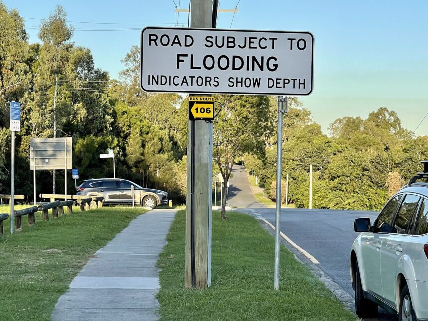
On floods, the page states that floods can occur almost anywhere in Queensland and can rise over days, or in minutes in a flash flood. It says: “Never drive through floodwater.” It also says never to try to drive over roads that have water over them. More than half of flood-related deaths, it says, are a result of driving through floodwater, and any amount of swift flowing water can sweep away a car, no matter what you drive.
Related News

Reopened roads need care too. Once floodwater starts to go down, the page says not to drive over the roads until the road is open again, and that road damage is sometimes not known until the road is completely dry and being driven on again. It says to drive carefully on reopened roads because they may still be drying out, and to look out for landslides. The “Flood barriers and signs” page (27 March 2017) puts it plainly: “Don’t risk it. If it’s flooded, forget it.”
What the signs mean
The “Flood barriers and signs” page, last updated 27 March 2017, says that even if floodwater has subsided, the road may not be safe to use, and that ignoring the signs may lead to a fine. A no entry sign means the road is temporarily closed to all traffic, which may be because it is damaged or flooded. A road closed ahead sign warns of a temporary closure coming up. Alternative route signs can show a detour if a road ahead is closed or flooded.
Roadworks are a related hazard: the “Road conditions and updates” page says you must take great care when driving through roadworks. Restricted road use notices limit use of a road, for example allowing only vehicles under 5 tonnes. Approval to drive past such a sign can be obtained for special reasons, but using a restricted road when you should not can attract a fine.
One sign deserves a careful read. The “Flood barriers and signs” page (27 March 2017) says the water over the road sign shows water over a road ahead, and that traffic can still pass with care and attention. The separate “Check road conditions” page (26 February 2024) tells drivers never to try to drive over roads that have water over them. This article does not reconcile the two wordings.
How current are these pages?
The “Flood barriers and signs” page shows a last updated date of 27 March 2017, and the “Check road conditions” page shows 26 February 2024. The “Road conditions and updates” page shows no date. Pages were read on 9 November 2026, and the wording may change. Read the full pages rather than relying on a summary.
Frequently asked questions
What number do I call for Queensland road conditions?
At 9 November 2026, QLDTraffic and the Queensland Government give 13 19 40, which QLDTraffic says operates 24/7 and can be reached from all states of Australia for information on major Queensland roads.
Is there a QLDTraffic app?
Yes. QLDTraffic says its app is available for iPhone and Android and offers personalised push notifications for alerts affecting favourite routes and places.
Can I drive through floodwater if it looks shallow?
The Queensland Government says never to drive through floodwater, and that any amount of swift flowing water can sweep away a car.
Why might a closure not appear on the website yet?
QLDTraffic says that for closures during significant weather events, information is updated once it is safe for TMR staff to do so.